
(Geological Exploration Of The Fortieth Parallel)
団長・クラランス・キング氏(のちのアメリカ地質調査所 初代所長)
前回に続き、アメリカ西部における地質探検調査団を取り上げ、米国国立公文書館(アメリカ国立公文書館)等の関連資料をご紹介いたします。
南北戦争後の1870 年代前後にかけて、連邦議会の承認を受けた地質調査団が4つ、それぞれ異なる地域を担ってアメリカ西部に派遣されています。
前回と今回ご紹介のものも、その中に含まれるものです。

このキング調査団は、北緯40度線を基準に、 経度120度から東方に経度105度まで 、(シエラネバダ山脈からロッキー山脈まで)、 セントラル・パシフィック鉄道とユニオン・パシフィック鉄道線路沿いも含めた地域を対象に、1年に5度を目安に調査を進めていく計画で結成されました。
その地域は、現在のカリフォルニア州、ネバダ州、ユタ州、ワイオミング州にかかります。
北緯40度線は、日本では秋田県や岩手県上にあります。
具体的な任務内容は、山脈や平原、河口の検分、また鉱石鉱物、土壌や岩石、塩類堆積物やアルカリ性堆積物の分析などを行うこと、さらに、主要な鉱物の物品採集と埋蔵地域地図作成、地形地図の作成や、気候に関する総合的な情報収集と記されています。
RG57, Records of the Geological Survey, King Survey; 1. LR, Chief Engineers & Treasury 1867-1870, 2. Records redd. from Treasury Dept, 1807-78 & from Public Printer 1871-1879, M-622, roll 1, No.3, 4
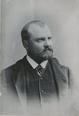
クラランス・キング氏(Clarence King )
RG 57-GP; Records of the U.S. Geological Survey, Portraits of Agency Personnel, ca. 1980 - ca. 2004, Box 1, Folder 1, No. 1

調査団は、Department of War (現Department of Defense; 国防総省)、米陸軍工兵隊(US Army Corps of Engineers)の責任者・ハンフリーズ将軍(General Andrew Atkinson Humphreys) 指揮下におかれました。
前回ご紹介のヘイデン調査団は、 内務省(Department of the Interior)の管轄下にありました。
カルフォルニア地質調査の経験のあるキング氏がこの任命を受けたのは、25歳のことでした。
RG57, Records of the Geological Survey, King Survey; Copies of letters & reports sent to Chief Engineers, March 1867 to January 1879; M-622, roll 3, No.1
初年度の調査団は、16人のメンバーでした。地質学者、地誌学者、植物学者、鳥類学者、古生物学者、カメラマンなどで構成され、軍の護衛も受けていました。
現地調査は 1868年度から1872年度の5年間(会計年度は7月〜翌年6月終了)。1年のうち、6月あたりから10月くらいまでを現場で調査活動を行う期間とし、その後は事務所を中継基地として構え、団員各自で、フィールド調査の続行、報告書作成に向けて分析や資料作成、次期調査計画をたて、事務処理などにもあてていました。
初年度には体調を崩す人が多かったそうです。
この年は、11月中旬から当時銀採掘で発展していたネバダ州バージニアシティを拠点として、当地の銀山(コムストック鉱床・Comestock Lode)を調査しました。

(左)バージニアシティ
77-KN-93 ½, American West Select List #152
View of Virginia City, Nev., from a nearby hillside, 1867-68.
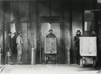
(右)コムストック鉱床、
鉱山の縦坑から運ばれてきた荷台。
77-KS-1-13; American West Select List #123;
Cars coming out of shaft, Comstock Mine, Virginia City, Nev. By O'Sullivan, 1867-68.
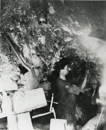
(左)ネバダ州バージニアシティ、
コムストック鉱床内で働く坑夫の様子
オーサリバン氏は、マグネシウムを燃やしフラッシュとして用いて撮影。
77-KS-1-15, American West Select List #122;
Miner working inside the Comstock Mine, Virginia City, Nev. Taken by O'Sullivan using the glare of burning magnesium for a flash of light, 1867-68.ー

この調査団のカメラマン、
ティモシー・オーサリバン氏。
(Timothy O'Sullivan)
Mr. Sullivan [i.e. O'Sullivan], Washington, D.C. : Wheeler & Angerman, No. 418 Seventh Street,
[ca. 1873]; LC-DIG-ppmsca-31600 (digital file from original item, front) ; Digital Id:
ppmsca 31600 //hdl.loc.gov/loc.pnp/ppmsca.31600
南北戦争時、従軍カメラマンであった経験も持つオーサリバン氏は、他の地質調査団にも協力しています。
1873年開催のウィーン万国博覧会に、調査団からの写真をアメリカ館に出品するよう要請されたという記録もありました。

オーサリバン氏の移動式スタジオ ネバダ州カルソン砂漠の砂丘にて 77-KS-3-160;
American West Select List #8; Timothy O'Sullivan's ambulance wagon and portable darkroom used during the King Survey rolls across the sand dunes of Carson Desert, Nev. By O'Sullivan, 1867.

ソーダ湖(東半分)、ネバダ州ラグタウン近く
Larger Soda Lake near Ragtown, Nevada (East half)
Photograph; 57-KSU-105; RG57-KSU; Record of the U.S. Geological Survey; Prints: Photographs from Geological Exploration of the 40th Parallel (King Survey), 1867-1872.

ネバダ州ピラミッド湖、ピラミッド湖とトゥファ(炭酸塩堆積物)の丘
Pyramid Lake, Nevada, Pyramid Island and tufa knobs (thinolite).
Photograph; 57-KSU-90; RG57-KSU; Record of the U.S. Geological Survey; Prints: Photographs from Geological Exploration of the 40th Parallel (King Survey), 1867-1872.

ワサッチ山脈、ユタ州ウィーバー・キャニオン
Wahsatch Mountains, Utah Weber Canyon, in Archean.
Photograph; 57-KSU-31; Photograph; 57-KSU-105; RG57-KSU; Record of the U.S. Geological Survey; Prints: Photographs from Geological Exploration of the 40th Parallel (King Survey), 1867-1872.
こちらのリンク先から、オーサリバン氏撮影の写真がステレオ写真でご覧いただけます。
https://catalog.archives.gov/search?q=*:*&f.ancestorNaIds=519540&sort=naIdSort%20asc&rows=100
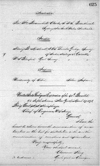
この遠征調査中、昇給や休暇申請といった待遇改善の交渉も記されていました。
1872年の春、キング氏と同僚のハーグ氏は、ハワイ州ホノルルへ6週間、
(船舶の都合により帰路1週間延期となり、結果7週間)の休暇を得ています。


休暇願い
RG57, Records of the Geological Survey, King Survey; Copies of letters & reports sent to Chief Engineers, March 1867 to January 1879; M-622, roll 3, No.335
休暇後の報告
RG57, Records of the Geological Survey, King Survey; Copies of letters & reports sent to Chief Engineers, March 1867 to January 1879; M-622, roll 3, No.337
休暇後、コロラド準州ではダイヤモンド鉱脈発見疑惑騒動が起こっていました。
ダイヤモンド鉱石発見の噂が騒ぎを起こし、大勢の人がその真偽を探りました。
その検証をキング氏グループが行い、ダイヤモンド鉱床ではないという結論を発表しました。

RG57, Records of the Geological Survey, King Survey; Copies of letters & reports sent to Chief Engineers, March 1867 to January 1879; M-622, roll 3, No.376-377
報告書の発行までには12年かかり、支出総額は、$521,851.90 と連邦議会に報告しています。


RG57, Records of the Geological Survey, King Survey; Copies of letters & reports sent to Chief Engineers, March 1867 to January 1879; M-622, roll 3, No.630,631,632
報告書7巻と地図は、以下のサイトからご覧になることができます。
1) VolumeⅠ: Systematic geology, by Clarence King, U. S. Geologist. 1878. 803 ページ
https://pubs.usgs.gov/unnumbered/70038097/report.pdf
2) Volume Ⅱ: Descriptive geology, by Arnold Hague and S. F. Emmons. 1877. 890 ぺージ
https://pubs.usgs.gov/unnumbered/70039217/report.pdf
3) Volume Ⅲ: Mining industry, by James D. Hague, with geological contributions by Clarence King. 1870. (647ページ). and atlas of 14 sheets.
https://www.biodiversitylibrary.org/item/111353#page/7/mode/1up
https://archive.org/details/atlas_mining_industry00newy (地図帳)
4) Volume Ⅳ; ParⅠ; Paleontology, by F. B. Meek, Part Ⅱ; Paleontology by James Hall and R. P. Whitfield, Part Ⅲ; Ornithology by Robert Ridgeway. 1877. (669ページ)
https://www.biodiversitylibrary.org/item/104531#page/7/mode/1up
5) Volume Ⅴ: Botany, by Sereno Watson, aided by Prof. Daniel C. Eaton and others. 1871. (525ページ)
https://pubs.usgs.gov/unnumbered/70039231/report.pdf
6) Volume Ⅵ: Microscopical petrography, by Ferdinand Zirkel. 1876. (297ページ+資料12ページ)
https://pubs.usgs.gov/unnumbered/70039233/report.pdf
7) Volume Ⅶ: Odontornithes, A monograph on the extinct toothed birds of North America, by Othniel Charles Marsh. 1880.(201ページ+資料68ページ)
https://www.biodiversitylibrary.org/item/124668#page/8/mode/1up
8) Atlases : Geological and Topographical Atlas, Accompanying the Report of the Geological Exploration of the Fortieth Parallel, Made by Authority of The Honorable Secretary of War, Under the Direction of Brig. and Brvt. Major General A. A. Humphreys, Chief Engineers U.S.A, By Clarence King, U.S. Geologist in Charge,1876
地図帳は、地質図部(10ページ)と地形図部(10ページ)の平面図と、陸地の高低差を示す断面図の2ページ、目次と解説、調査対象地域の山系地図からなります。
地質図と地形図は、描写範囲を同じくして2枚開きで描かれ、それが5組あり、調査全範囲をカバーしています。上記サイトでは地質図と地形図をそれぞれひとつに繋げて見せてくれます。
内表紙

陸地断面図

ロッキー山脈 地質図と地形図

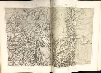
ネバダ盆地 地質図と地形図


調査団のこれらの報告書は、全米や海外の個人、大学、研究機関、図書館等に送られています。
キング氏依頼の送付先リストの中には、東京大学の名前もありました。
RG57, Records of the Geological Survey, King Survey; Copies of letters & reports sent to Chief Engineers, March 1867 to January 1879; M-622, roll 3, No.625
報告書を発行し、事務整理を終えて、この調査は満了となりました。
調査団の通信記録追跡は、経過を辿ることができ大変面白いものでした。
この調査事業を成し遂げることで自分たちの国アメリカの威信を示すという、気概を持ったキング調査団の様子を窺い知れました。
この調査団と同時期の他3つの調査団の成果をまとめる形で、1879年、アメリカ地質調査所 (United States Geological Survey, 本部;バージニア州レストン) が開設されました。
キング氏はその初代所長に任命されました。
(NK)